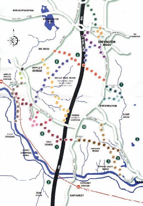
Points of interest:

The memorial to a 19th century mining disaster. The southern and western parish boundaries are created by the Leeds and Liverpool canal with a tow-path from Crooke to Appley Bridge.

Gathurst Locks, where river navigation and canal come together, as do industry and engineering from the 18th Century, the railway from the 19th, and the M6 viaduct, an endlessly noisy memorial to the 20th Century. The motorway itself bisects the parish from north to south.


Footbridges crossing the motorway on paths 5 and 9. To look down on the speeding traffic from a path is to be reminded how much longer the path has been there and what a different, slower world it served. Today there are paths for leisurely walking or sometimes jogging but once they were paths linking the communities that make up the parish. Sometimes they still do.

The footpath from Church Lane to Crooke Village is much walked and takes you into one of the most fascinating communities in the whole of Wigan Borough; a single street consisting of houses, a pub, a village green, a Methodist Chapel, and the canal with moorings for narrowboats. Although it is only yards from the main road, it retains a sense of being a community with its own character, living on its own.

As you head just east of north, you have tracts of 60s and 70s housing to the west. Half hidden by trees over 150 years old, the marker directing you across the open field is the TV mast on Winter Hill, 8 miles away on top of the West Pennine Moors.

As you walk down into Elnup Wood past a newly excavated water mill, evidence of the long history of agriculture in what is still a rural, wooded and farmed parish.
From the paths, the houses and even the massive buildings spurt of the 60s and 70s disappear in the surprisingly densely wooded countryside.

Across Gathurst Golf Club fairways, you see ducks living in the ponds that dot the very pretty course. While players are reminded that walkers on the path have right of way, a golf ball does not know about rights of way, so take care when you cross the course!
There is a heronry on the river to the west and walkers on the canal path can often find themselves accompanied by a kingfisher as well as mallards and water hens. There are always kestrels but a careful watch on the edge of the woods will let you see a sparrowhawk. If you are very lucky you might see a deer. The stretches of open water at Wrightington and the relative closeness of Martin Mere mean that skeins of geese and swans overfly the parish, particularly in spring and autumn.

Here you will find a remarkable wetland area of dense willow and birch scrub; a good place to see long-tailed tits and to hear the brilliant song of the black caps.

All the paths cross the main roads and in the centre of Shevington, opposite the Plough and Harrow, there is a parish council car park with an adjacent bus stop which sets down passengers from Wigan and beyond.
There are railway stations at Gathurst and Appley Bridge on the Manchester to Southport line and both are close to the canal tow-path where it is possible to cycle as well as walk.
Back to Community Page
Back to Council Page
©2003 Shevington Parish Council
Contact Us: Contact the Parish Clerk
Contact Us: Contact the Website
